 The Pipalyatjara Community
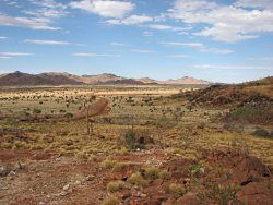
Pipalyatjara is located approximately 200 km south west of Uluru (Ayers Rock) in South Australia. The Community occupies part of the Anangu Pitjantjatjara Lands (APY Lands) in the north west of South Australia. The Pitjantjatjara country consists of a long chain of mountain ranges, the Musgraves, Mann and Tomkinsons, stretching east to west on the southern side of the Northern Territory border, isolated ranges and hills and extensive sandhill plains. APY also has affiliations with land in the Northern Territory to the Petermann Ranges and in Western Australia.
Content and Purpose of the Community Structure Plan
The Pipalyatjara Community Structure Plan (Structure Plan) provides a framework within which development can proceed in an orderly and planned manner and essential services are protected over the next 5 to 10 years.
The Structure Plan consists of the following:
- A plan depicting the physical layout of the community;
- Strategic direction, planning objectives and development guidelines;
- An explanation of the Structure Plan;
- A report on the preparation of the plan including an overview of local and regional context.
The purpose of the Structure Plan is therefore to:
- Establish an outline vision for the community and a guide to future growth and development of the community;
- Provide a community focus for, and involvement in, the development process;
- Facilitate proper and orderly planning of the community to establish development requirements based on need within social, physical, environmental and economic opportunities and constraints;
- Provide a mechanism for a coordinated approach to the provisions of services and infrastructure and enable access to existing services and infrastructure information; and
- Promote development that maximises health, safety and welfare outcomes for the community.
The structure plan provides the community with a plan that forms the basis for coordination of future development. The Plan can be used to assess future development proposals by government agencies, builders, funding agencies and the community.
pdf
Pipalytatjara Community Structure Plan
The Kalka Community
Kalka Community is located in the far northwest of South Australia, just a few kilometres from Surveyor General’s Corner where Western Australia, South Australia and Northern Territory meet. Kalka is about 700 kms by road or 2 hours by plane from Alice Springs.
Kalka Community is nestled beside the Tomkinson Range in a picturesque location overlooking savannah and nearby hills. Summer temperatures (between December and February) can be quite hot but the rest of the year is generally mild to warm during the day. Summer rains usually fill several waterholes in the region that are used for swimming.
The population of Kalka (2004) was 150 with regular fluctuations up to 200 Anangu. A small non-Anangu population of community and nursing staff also resides at Kalka. The homeland areas, covering approximately 4,000 square kms, continue to be of central importance culturally as well as being a resource for tourism, mineral exploration and other development.
Access to the community is by plane (once per week from Alice Springs) and by road (turn off the Stuart Highway 45 kms north of Marla, or off the Lasseter Highway 20 kms east of Curtain Springs). A fortnightly truck brings fresh, frozen and dry groceries, as well as other freight to the community.
Due to historical quirks of fate, while Kalka has the largest Anangu population in the far western Anangu Pitjantjatjara Yankunytjatjara Lands, some services, such as the regional school and health clinic, are located at nearby Pipalyatjara, about 15 km away. An Essential Services Officer works between Pipalyatjara and Kalka communities maintaining power and water supplies. Other infrastructure development has been relatively slow to occur at Kalka and is only now being addressed. An infrastructure plan that was finalised in 2004 details the street, essential service and housing requirements for the community well into the future.
Kalka is a small community with basic facilities: a small community store, arts centre, TAFE training centre, kitchen for meals on wheels and other programs, mechanical workshop, recreation shed, administration office and various storage sheds and yards. There is a staff house, a visitor’s house and nurses houses, as well as housing for Anangu residents. Other buildings include an additional staff house, additional visitors’ quarters, regional aged accommodation facility, regional training facility and rural transaction centre.
Despite some underlying problems common to many communities of relatively poor indigenous people Kalka is generally a happy, peaceful community. Anangu enjoy going out hunting and gathering many different bush foods when they are in season as well as producing a wide range of art and craft works. The young men and women participate in regional football and softball competitions. Traditional cultural practices and concerns are very important and form part of the daily and annual life of the community.